Make a donation
Gear up for your next adventure:
As an Amazon Associate, this site earns from qualifying purchases at no extra cost to you.
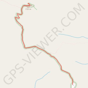
Hurricane Hill Nature Trail in Olympic National Park
The Hurricane Hill Nature Trail offers a relatively easy, yet rewarding hike within Olympic National Park, providing stunning panoramic views from Hurricane Ridge. As you ascend, you'll be treated to sweeping vistas of snow-capped peaks, including Mount Olympus, while also spotting vibrant wildflower meadows and the potential for wildlife sightings like deer, mountain goats, and marmots. The trail, with its paved surface, is accessible year-round and offers excellent views of the Strait of Juan de Fuca and the surrounding mountains, making it an ideal choice for those seeking both scenic beauty and a moderate adventure. #Hiking #Mountain #Forest #Nature
- Distance: 1.6 mi
- Elevation gain: 797 ft
- Maximum elevation: 5,719 ft
- Elevation loss: 138 ft
- Minimum elevation: 5,007 ft
Interactive trail map
Make a donation
Gear up for your next adventure:
As an Amazon Associate, this site earns from qualifying purchases at no extra cost to you.
Trail profile
- Distance: 1.6 mi
- Elevation gain: 797 ft
- Maximum elevation: 5,719 ft
- Elevation loss: 138 ft
- Minimum elevation: 5,007 ft
Make a donation
Gear up for your next adventure:
As an Amazon Associate, this site earns from qualifying purchases at no extra cost to you.
About this trail
Name: Hurricane Hill Nature Trail in Olympic National Park trail, distance, elevation, map, profile, GPS track
End: Hurricane Hill Nature Trail, Clallam County, Washington, United States (47.99032 -123.52905)
Coordinates: 47.97649 -123.53236 47.99032 -123.51775
Topography: Clallam County topographic map, elevation, terrain
Make a donation
Gear up for your next adventure:
As an Amazon Associate, this site earns from qualifying purchases at no extra cost to you.
Other hiking, mountain biking, running and outdoor activity trails
Click on a trail to view its statistics, map and profile.
Hurricane Hill (Olympic National Park)
United States > Washington > Clallam County
Hike to Hurricane Hill via Big Meadow Nature Trail, Cirque Rim Nature Trail, Little River Viewpoint Nature Trail, Hurricane Ridge Road and Hurricane Hill Nature Trail in the Daniel J. Evans Wilderness and the Olympic National Park. #Hile #Mountain #Nature #Forest #Park #Olympic #Wilderness
Distance: 6.5 mi • Elevation gain: 1,473 ft • Maximum elevation: 5,712 ft