Thank you for supporting this site ❤️
Make a donation
Make a donation
Gear up for your next adventure:
As an Amazon Associate, this site earns from qualifying purchases at no extra cost to you.
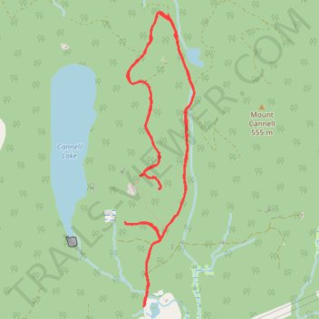
Hunter Trail
- Distance: 6.4 mi
- Elevation gain: 1,450 ft
- Maximum elevation: 1,526 ft
- Elevation loss: 1,450 ft
- Minimum elevation: 600 ft
- Moving time: 3 h 26 m
- Moving speed: 1.9 mph
- Maximum speed: 3.5 mph
- Total time: 5 h 15 m
- Global speed: 1.2 mph
Interactive trail map
Thank you for supporting this site ❤️
Make a donation
Make a donation
Gear up for your next adventure:
As an Amazon Associate, this site earns from qualifying purchases at no extra cost to you.
Trail profile
- Distance: 6.4 mi
- Elevation gain: 1,450 ft
- Maximum elevation: 1,526 ft
- Elevation loss: 1,450 ft
- Minimum elevation: 600 ft
- Moving time: 3 h 26 m
- Moving speed: 1.9 mph
- Maximum speed: 3.5 mph
- Total time: 5 h 15 m
- Global speed: 1.2 mph
Thank you for supporting this site ❤️
Make a donation
Make a donation
Gear up for your next adventure:
As an Amazon Associate, this site earns from qualifying purchases at no extra cost to you.
About this trail
Name: Hunter Trail trail, distance, elevation, map, profile, GPS track
Coordinates: 49.24815 -122.30501 49.27032 -122.29704
Thank you for supporting this site ❤️
Make a donation
Make a donation
Gear up for your next adventure:
As an Amazon Associate, this site earns from qualifying purchases at no extra cost to you.
Other hiking, mountain biking, running and outdoor activity trails
Click on a trail to view its statistics, map and profile.