Eakin Park
- Distance: 1.9 mi
- Elevation gain: 62 ft
- Maximum elevation: 302 ft
- Elevation loss: 62 ft
- Minimum elevation: 276 ft
- Moving time: 47 m 4 s
- Moving speed: 2.4 mph
- Maximum speed: 14.8 mph
- Total time: 51 m 14 s
- Global speed: 2.2 mph
Interactive trail map
Trail profile
- Distance: 1.9 mi
- Elevation gain: 62 ft
- Maximum elevation: 302 ft
- Elevation loss: 62 ft
- Minimum elevation: 276 ft
- Moving time: 47 m 4 s
- Moving speed: 2.4 mph
- Maximum speed: 14.8 mph
- Total time: 51 m 14 s
- Global speed: 2.2 mph
About this trail
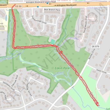
Name: Eakin Park trail, distance, elevation, map, profile, GPS track
End: CCT, Boulevard Estates, Mantua, Fairfax County, Virginia, 22031, United States (38.86479 -77.26147)
Coordinates: 38.85714 -77.26155 38.86520 -77.25274
Topography: Fairfax County topographic map, elevation, terrain