Thank you for supporting this site ❤️
Make a donation
Make a donation
Gear up for your next adventure:
As an Amazon Associate, this site earns from qualifying purchases at no extra cost to you.
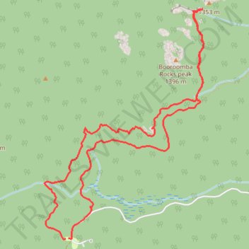
Honeysuckle Creek Tracking Station to Booroomba Rocks
- Distance: 6.7 mi
- Elevation gain: 1,234 ft
- Maximum elevation: 4,383 ft
- Elevation loss: 1,234 ft
- Minimum elevation: 3,451 ft
- Moving time: 1 h 26 m
- Moving speed: 4.6 mph
- Maximum speed: 8.9 mph
- Total time: 1 h 28 m
- Global speed: 4.5 mph
Interactive trail map
Thank you for supporting this site ❤️
Make a donation
Make a donation
Gear up for your next adventure:
As an Amazon Associate, this site earns from qualifying purchases at no extra cost to you.
Trail profile
- Distance: 6.7 mi
- Elevation gain: 1,234 ft
- Maximum elevation: 4,383 ft
- Elevation loss: 1,234 ft
- Minimum elevation: 3,451 ft
- Moving time: 1 h 26 m
- Moving speed: 4.6 mph
- Maximum speed: 8.9 mph
- Total time: 1 h 28 m
- Global speed: 4.5 mph
Thank you for supporting this site ❤️
Make a donation
Make a donation
Gear up for your next adventure:
As an Amazon Associate, this site earns from qualifying purchases at no extra cost to you.
About this trail
Name: Honeysuckle Creek Tracking Station to Booroomba Rocks trail, distance, elevation, map, profile, GPS track
Coordinates: -35.58306 148.97132 -35.55693 148.99360
Thank you for supporting this site ❤️
Make a donation
Make a donation
Gear up for your next adventure:
As an Amazon Associate, this site earns from qualifying purchases at no extra cost to you.
Other hiking, mountain biking, running and outdoor activity trails
Click on a trail to view its statistics, map and profile.
Cloudride24.FINAL
Distance: 639.3 mi • Elevation gain: 69,823 ft • Maximum elevation: 5,755 ft