Thank you for supporting this site ❤️
Make a donation
Make a donation
Gear up for your next adventure:
As an Amazon Associate, this site earns from qualifying purchases at no extra cost to you.
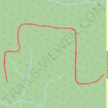
Tree farm in Hansville
- Distance: 1.8 mi
- Elevation gain: 174 ft
- Maximum elevation: 371 ft
- Elevation loss: 174 ft
- Minimum elevation: 269 ft
- Moving time: 18 m 54 s
- Moving speed: 5.7 mph
- Maximum speed: 11.2 mph
- Total time: 18 m 54 s
- Global speed: 5.7 mph
Interactive trail map
Thank you for supporting this site ❤️
Make a donation
Make a donation
Gear up for your next adventure:
As an Amazon Associate, this site earns from qualifying purchases at no extra cost to you.
Trail profile
- Distance: 1.8 mi
- Elevation gain: 174 ft
- Maximum elevation: 371 ft
- Elevation loss: 174 ft
- Minimum elevation: 269 ft
- Moving time: 18 m 54 s
- Moving speed: 5.7 mph
- Maximum speed: 11.2 mph
- Total time: 18 m 54 s
- Global speed: 5.7 mph
Thank you for supporting this site ❤️
Make a donation
Make a donation
Gear up for your next adventure:
As an Amazon Associate, this site earns from qualifying purchases at no extra cost to you.
About this trail
Name: Tree farm in Hansville trail, distance, elevation, map, profile, GPS track
Coordinates: 47.85755 -122.55076 47.86127 -122.54155
Topography: Kitsap County topographic map, elevation, terrain
Thank you for supporting this site ❤️
Make a donation
Make a donation
Gear up for your next adventure:
As an Amazon Associate, this site earns from qualifying purchases at no extra cost to you.