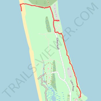
Saint Joseph Peninsula Nature Trail
- Distance: 1.5 mi
- Elevation gain: 43 ft
- Maximum elevation: 23 ft
- Elevation loss: 43 ft
- Minimum elevation: -3 ft
- Moving time: 47 m 46 s
- Moving speed: 1.8 mph
- Maximum speed: 4.1 mph
- Total time: 49 m 16 s
- Global speed: 1.8 mph
Interactive trail map
Trail profile
- Distance: 1.5 mi
- Elevation gain: 43 ft
- Maximum elevation: 23 ft
- Elevation loss: 43 ft
- Minimum elevation: -3 ft
- Moving time: 47 m 46 s
- Moving speed: 1.8 mph
- Maximum speed: 4.1 mph
- Total time: 49 m 16 s
- Global speed: 1.8 mph
About this trail
Name: Saint Joseph Peninsula Nature Trail trail, distance, elevation, map, profile, GPS track
Start: Nature Trail, Gulf County, Florida, United States (29.77668 -85.40183)
End: Cabin Road, Gulf County, Florida, United States (29.78840 -85.41084)
Coordinates: 29.77668 -85.41107 29.78940 -85.40155
Topography: Gulf County topographic map, elevation, terrain