Make a donation
Gear up for your next adventure:
As an Amazon Associate, this site earns from qualifying purchases at no extra cost to you.
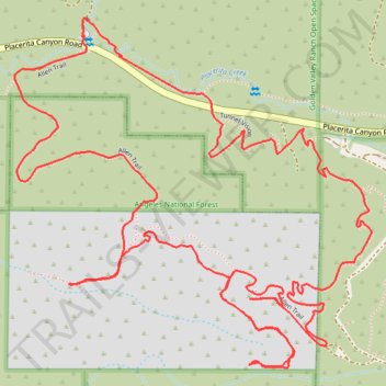
Walker Ranch Open Space
- Distance: 3.7 mi
- Elevation gain: 653 ft
- Maximum elevation: 2,251 ft
- Elevation loss: 653 ft
- Minimum elevation: 1,867 ft
- Moving time: 53 m 53 s
- Moving speed: 4.2 mph
- Maximum speed: 20.0 mph
- Total time: 1 h 18 m
- Global speed: 2.9 mph
Interactive trail map
Make a donation
Gear up for your next adventure:
As an Amazon Associate, this site earns from qualifying purchases at no extra cost to you.
Trail profile
- Distance: 3.7 mi
- Elevation gain: 653 ft
- Maximum elevation: 2,251 ft
- Elevation loss: 653 ft
- Minimum elevation: 1,867 ft
- Moving time: 53 m 53 s
- Moving speed: 4.2 mph
- Maximum speed: 20.0 mph
- Total time: 1 h 18 m
- Global speed: 2.9 mph
Make a donation
Gear up for your next adventure:
As an Amazon Associate, this site earns from qualifying purchases at no extra cost to you.
About this trail
Name: Walker Ranch Open Space trail, distance, elevation, map, profile, GPS track
Coordinates: 34.37078 -118.43964 34.37907 -118.42939
Topography: Santa Clarita topographic map, elevation, terrain
Make a donation
Gear up for your next adventure:
As an Amazon Associate, this site earns from qualifying purchases at no extra cost to you.
Other hiking, mountain biking, running and outdoor activity trails
Click on a trail to view its statistics, map and profile.
East Walker Ranch Open Space - Angeles National Forest
United States > California > Los Angeles County > Santa Clarita
Distance: 3.9 mi • Elevation gain: 774 ft • Maximum elevation: 2,356 ft
East Walker Ranch - Keely Trail Downhill
United States > California > Los Angeles County > Santa Clarita
Distance: 1.4 mi • Elevation gain: 259 ft • Maximum elevation: 2,254 ft