Thank you for supporting this site ❤️
Make a donation
Make a donation
Gear up for your next adventure:
As an Amazon Associate, this site earns from qualifying purchases at no extra cost to you.
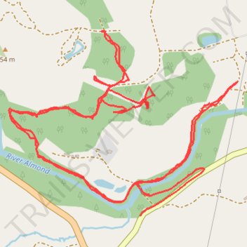
River Almond path at Dallick and connecting to other tracks
- Distance: 3.9 mi
- Elevation gain: 404 ft
- Maximum elevation: 843 ft
- Elevation loss: 430 ft
- Minimum elevation: 627 ft
- Moving time: 1 h 33 m
- Moving speed: 2.5 mph
- Maximum speed: 10.6 mph
- Total time: 1 h 41 m
- Global speed: 2.3 mph
Interactive trail map
Thank you for supporting this site ❤️
Make a donation
Make a donation
Gear up for your next adventure:
As an Amazon Associate, this site earns from qualifying purchases at no extra cost to you.
Trail profile
- Distance: 3.9 mi
- Elevation gain: 404 ft
- Maximum elevation: 843 ft
- Elevation loss: 430 ft
- Minimum elevation: 627 ft
- Moving time: 1 h 33 m
- Moving speed: 2.5 mph
- Maximum speed: 10.6 mph
- Total time: 1 h 41 m
- Global speed: 2.3 mph
Thank you for supporting this site ❤️
Make a donation
Make a donation
Gear up for your next adventure:
As an Amazon Associate, this site earns from qualifying purchases at no extra cost to you.
About this trail
Name: River Almond path at Dallick and connecting to other tracks trail, distance, elevation, map, profile, GPS track
Coordinates: 56.43614 -3.77249 56.44286 -3.75749
Thank you for supporting this site ❤️
Make a donation
Make a donation
Gear up for your next adventure:
As an Amazon Associate, this site earns from qualifying purchases at no extra cost to you.