Make a donation
Gear up for your next adventure:
As an Amazon Associate, this site earns from qualifying purchases at no extra cost to you.
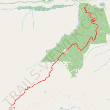
North Mount Elbert Trail
Interactive trail map
Make a donation
Gear up for your next adventure:
As an Amazon Associate, this site earns from qualifying purchases at no extra cost to you.
Trail profile
- Distance: 10.1 mi
- Elevation gain: 4,442 ft
- Maximum elevation: 14,403 ft
- Elevation loss: 4,442 ft
- Minimum elevation: 10,079 ft
- Moving time: 4 h 55 m
- Moving speed: 2.1 mph
- Maximum speed: 6.8 mph
- Total time: 6 h 17 m
- Global speed: 1.6 mph
Make a donation
Gear up for your next adventure:
As an Amazon Associate, this site earns from qualifying purchases at no extra cost to you.
About this trail
Name: North Mount Elbert Trail trail, distance, elevation, map, profile, GPS track
Coordinates: 39.11764 -106.44539 39.15169 -106.40802
Topography: Lake County topographic map, elevation, terrain
Make a donation
Gear up for your next adventure:
As an Amazon Associate, this site earns from qualifying purchases at no extra cost to you.
Other hiking, mountain biking, running and outdoor activity trails
Click on a trail to view its statistics, map and profile.
North Mount Elbert Trail in San Isabel National Forest
United States > Colorado > Lake County
The North Mount Elbert Trail offers hikers a challenging yet rewarding journey through diverse landscapes, starting with dense forests of aspen and pine, and leading to the summit of Colorado's highest peak. As you ascend above the treeline, expansive views unfold, showcasing the Twin Lakes nestled amidst the…
Distance: 10.1 mi • Elevation gain: 4,511 ft • Maximum elevation: 14,400 ft
Continental Divide Trail (CDT)
United States > Colorado > Lake County
Hike on the Continental Divide National Scenic Trail between Halfmoon Creek and Copper Mountain through Mount Massive Wilderness, Holy Cross Wilderness, White River National Forest and Continental Divide National Monument in the Rocky Mountains. #Hiking #CDT #Mountain #Nature #River
Distance: 49.0 mi • Elevation gain: 9,209 ft • Maximum elevation: 12,277 ft