Make a donation
Gear up for your next adventure:
As an Amazon Associate, this site earns from qualifying purchases at no extra cost to you.
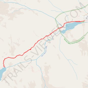
Crater Lake and Maroon Lake
Via Maroon-Snowmass Trail in Maroon Bells-Snowmass Wilderness #Hiking #Lake #Mountain
- Distance: 3.6 mi
- Elevation gain: 705 ft
- Maximum elevation: 10,184 ft
- Elevation loss: 705 ft
- Minimum elevation: 9,596 ft
- Moving time: 1 h 34 m
- Moving speed: 2.3 mph
- Maximum speed: 3.5 mph
- Total time: 2 h 4 m
- Global speed: 1.7 mph
Interactive trail map
Make a donation
Gear up for your next adventure:
As an Amazon Associate, this site earns from qualifying purchases at no extra cost to you.
Trail profile
- Distance: 3.6 mi
- Elevation gain: 705 ft
- Maximum elevation: 10,184 ft
- Elevation loss: 705 ft
- Minimum elevation: 9,596 ft
- Moving time: 1 h 34 m
- Moving speed: 2.3 mph
- Maximum speed: 3.5 mph
- Total time: 2 h 4 m
- Global speed: 1.7 mph
Make a donation
Gear up for your next adventure:
As an Amazon Associate, this site earns from qualifying purchases at no extra cost to you.
About this trail
Name: Crater Lake and Maroon Lake trail, distance, elevation, map, profile, GPS track
Start: Maroon Lake Trail, Pitkin County, Colorado, United States (39.09846 -106.94094)
End: Maroon Lake Trail, Pitkin County, Colorado, United States (39.09850 -106.94088)
Coordinates: 39.08725 -106.96611 39.09850 -106.94088
Topography: Pitkin County topographic map, elevation, terrain
Make a donation
Gear up for your next adventure:
As an Amazon Associate, this site earns from qualifying purchases at no extra cost to you.
Other hiking, mountain biking, running and outdoor activity trails
Click on a trail to view its statistics, map and profile.
Crater Lake and Maroon Lake via Maroon-Snowmass Trail
United States > Colorado > Pitkin County
The Crater Lake Trail in Colorado's Maroon Bells-Snowmass Wilderness offers hikers a moderately challenging journey through dense aspen and conifer forests, leading to the serene Crater Lake nestled beneath the towering Maroon Bells peaks. Along the path, adventurers traverse rocky terrains and alpine meadows,…
Distance: 3.6 mi • Elevation gain: 679 ft • Maximum elevation: 10,184 ft