Around Tiddesley Wood
- Distance: 12.1 mi
- Elevation gain: 630 ft
- Maximum elevation: 184 ft
- Elevation loss: 633 ft
- Minimum elevation: 36 ft
- Moving time: 4 h 6 m
- Moving speed: 2.9 mph
- Maximum speed: 5.0 mph
- Total time: 5 h 25 m
- Global speed: 2.2 mph
Interactive trail map
Trail profile
- Distance: 12.1 mi
- Elevation gain: 630 ft
- Maximum elevation: 184 ft
- Elevation loss: 633 ft
- Minimum elevation: 36 ft
- Moving time: 4 h 6 m
- Moving speed: 2.9 mph
- Maximum speed: 5.0 mph
- Total time: 5 h 25 m
- Global speed: 2.2 mph
About this trail
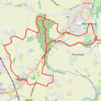
Name: Around Tiddesley Wood trail, distance, elevation, map, profile, GPS track
Coordinates: 52.08463 -2.13130 52.11341 -2.07054
Other hiking, mountain biking, running and outdoor activity trails
Click on a trail to view its statistics, map and profile.
Pershore
United Kingdom > England > Worcestershire > Wychavon > Pershore
Distance: 4.7 mi • Elevation gain: 262 ft • Maximum elevation: 184 ft