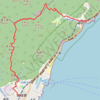
航跡
- Distance: 9.4 mi
- Elevation gain: 2,740 ft
- Maximum elevation: 2,313 ft
- Elevation loss: 2,746 ft
- Minimum elevation: 23 ft
Interactive trail map
Trail profile
- Distance: 9.4 mi
- Elevation gain: 2,740 ft
- Maximum elevation: 2,313 ft
- Elevation loss: 2,746 ft
- Minimum elevation: 23 ft
About this trail
Name: 航跡 trail, distance, elevation, map, profile, GPS track
Start: 濱海路三段, Gengxin Village, Toucheng Township, Yilan County, 261, Taiwan (24.90453 121.86868)
End: 頭城車站, 59, 纘祥路, Chengbei Village, Toucheng Township, Yilan County, 261, Taiwan (24.85879 121.82257)
Coordinates: 24.85842 121.81593 24.91435 121.86868