Make a donation
Gear up for your next adventure:
As an Amazon Associate, this site earns from qualifying purchases at no extra cost to you.
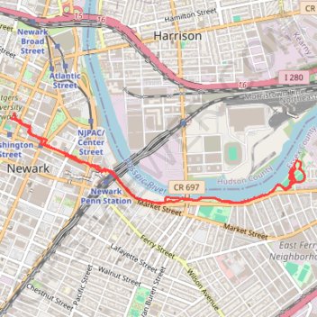
Ironbound playground
- Distance: 5.0 mi
- Elevation gain: 217 ft
- Maximum elevation: 75 ft
- Elevation loss: 223 ft
- Minimum elevation: 0 ft
- Moving time: 1 h 13 m
- Moving speed: 4.0 mph
- Maximum speed: 17.2 mph
- Total time: 1 h 43 m
- Global speed: 2.9 mph
Interactive trail map
Make a donation
Gear up for your next adventure:
As an Amazon Associate, this site earns from qualifying purchases at no extra cost to you.
Trail profile
- Distance: 5.0 mi
- Elevation gain: 217 ft
- Maximum elevation: 75 ft
- Elevation loss: 223 ft
- Minimum elevation: 0 ft
- Moving time: 1 h 13 m
- Moving speed: 4.0 mph
- Maximum speed: 17.2 mph
- Total time: 1 h 43 m
- Global speed: 2.9 mph
Make a donation
Gear up for your next adventure:
As an Amazon Associate, this site earns from qualifying purchases at no extra cost to you.
About this trail
Name: Ironbound playground trail, distance, elevation, map, profile, GPS track
Coordinates: 40.73276 -74.17407 40.74012 -74.14251
Topography: Newark topographic map, elevation, terrain
Make a donation
Gear up for your next adventure:
As an Amazon Associate, this site earns from qualifying purchases at no extra cost to you.
Other hiking, mountain biking, running and outdoor activity trails
Click on a trail to view its statistics, map and profile.
Branch Brook Park Loop
United States > New Jersey > Essex County > Newark
Afternoon Ride
Distance: 11.1 mi • Elevation gain: 509 ft • Maximum elevation: 157 ft
Newark - Belleville
United States > New Jersey > Essex County > Newark > Roseville
Evening Ride
Distance: 11.3 mi • Elevation gain: 541 ft • Maximum elevation: 157 ft
Ironbound, Harrison
United States > New Jersey > Essex County > Newark
Distance: 8.8 mi • Elevation gain: 420 ft • Maximum elevation: 112 ft
Make a donation
Gear up for your next adventure:
As an Amazon Associate, this site earns from qualifying purchases at no extra cost to you.
Cherry blossom
United States > New Jersey > Essex County > Newark
Evening Ride
Distance: 12.1 mi • Elevation gain: 535 ft • Maximum elevation: 148 ft
Afternoon Ride
United States > New Jersey > Essex County > Newark
Distance: 13.0 mi • Elevation gain: 650 ft • Maximum elevation: 177 ft
Cedar Grove
United States > New Jersey > Essex County > Newark
Afternoon Ride
Distance: 26.8 mi • Elevation gain: 1,309 ft • Maximum elevation: 535 ft