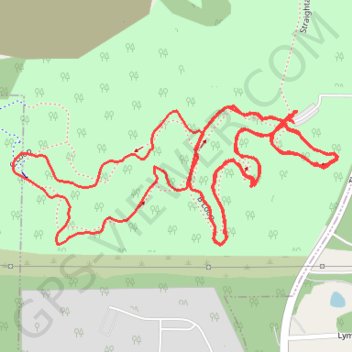
Hampton Hills MTB A, B, and C loops, multiband x2
Akron Mountain Biking
- Distance: 3.6 mi
- Elevation gain: 148 ft
- Maximum elevation: 942 ft
- Elevation loss: 148 ft
- Minimum elevation: 902 ft
- Moving time: 39 m 39 s
- Moving speed: 5.4 mph
- Maximum speed: 9.3 mph
- Total time: 42 m 39 s
- Global speed: 5.1 mph
Interactive trail map
Trail profile
- Distance: 3.6 mi
- Elevation gain: 148 ft
- Maximum elevation: 942 ft
- Elevation loss: 148 ft
- Minimum elevation: 902 ft
- Moving time: 39 m 39 s
- Moving speed: 5.4 mph
- Maximum speed: 9.3 mph
- Total time: 42 m 39 s
- Global speed: 5.1 mph
About this trail
Name: Hampton Hills MTB A, B, and C loops, multiband x2 trail, distance, elevation, map, profile, GPS track
Coordinates: 41.14864 -81.55734 41.15109 -81.54973
Topography: Akron topographic map, elevation, terrain
Other hiking, mountain biking, running and outdoor activity trails
Click on a trail to view its statistics, map and profile.
Hampton Hills MTB D Loop
United States > Ohio > Summit County > Akron
Akron Mountain Biking
Distance: 6.5 mi • Elevation gain: 371 ft • Maximum elevation: 942 ft