A nice walk
Lunch Workout
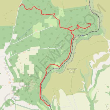
- Distance: 11.1 mi
- Elevation gain: 1,302 ft
- Maximum elevation: 856 ft
- Elevation loss: 1,388 ft
- Minimum elevation: 223 ft
- Moving time: 3 h 21 m
- Moving speed: 3.3 mph
- Maximum speed: 12.6 mph
- Total time: 3 h 38 m
- Global speed: 3.1 mph
Interactive trail map
Trail profile
- Distance: 11.1 mi
- Elevation gain: 1,302 ft
- Maximum elevation: 856 ft
- Elevation loss: 1,388 ft
- Minimum elevation: 223 ft
- Moving time: 3 h 21 m
- Moving speed: 3.3 mph
- Maximum speed: 12.6 mph
- Total time: 3 h 38 m
- Global speed: 3.1 mph
About this trail
Name: A nice walk trail, distance, elevation, map, profile, GPS track
Coordinates: 54.30834 -0.76953 54.35743 -0.71075
Other hiking, mountain biking, running and outdoor activity trails
Click on a trail to view its statistics, map and profile.
Newton Upon Rawcliffe Loop Mountain Biking
United Kingdom > England > North Yorkshire > Newton upon Rawcliffe
Distance: 16.5 mi • Elevation gain: 1,929 ft • Maximum elevation: 853 ft
Levisham Moor, Simon's Howe and Fylingdales Moor Loop
United Kingdom > England > North Yorkshire
Distance: 19.2 mi • Elevation gain: 1,785 ft • Maximum elevation: 951 ft
Levisham Loop Walk
United Kingdom > England > North Yorkshire > Levisham
Distance: 5.6 mi • Elevation gain: 896 ft • Maximum elevation: 620 ft