Rondje Nunspeet: water, bos en heide
<p>Na een kop koffie bij Bakkerij en Lunchroom Uniek rijd je over landelijke weggetjes richting het Veluwemeer. Een prachtig vrij liggend fietspad tussen de graslanden door leidt je naar het zeventiende-eeuwse Kasteel De Essenburgh. Hier buig je af naar de bossen aan de noordkant van de Veluwe. Je vindt hier ook veel heide: je steekt bijvoorbeeld de Elspeetse Heide over, met zijn heideschapen en eeuwenoude grafheuvels. Wat een afwisseling! Op de terugweg heb je vanaf de Oude Zeeweg een mooi uitzicht over het Veluwemeer. De naam van de weg herinnert natuurlijk aan de Zuiderzee. Vanwege de veiligheid, maar ook omdat er door de Eerste Wereldoorlog een voedseltekort was ontstaan en op Flevoland kon nieuwe landbouwgrond worden gecreëerd. Nu is de Veluwemeer regio een geliefd gebied voor watersporters – en fietsers!</p>
- Distance: 36.6 mi
- Elevation gain: 610 ft
- Maximum elevation: 200 ft
- Elevation loss: 610 ft
- Minimum elevation: -3 ft
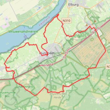
Interactive trail map
Trail profile
- Distance: 36.6 mi
- Elevation gain: 610 ft
- Maximum elevation: 200 ft
- Elevation loss: 610 ft
- Minimum elevation: -3 ft
About this trail
Name: Rondje Nunspeet: water, bos en heide trail, distance, elevation, map, profile, GPS track
Coordinates: 52.31957 5.68531 52.43157 5.91316