Thank you for supporting this site ❤️
Make a donation
Make a donation
Gear up for your next adventure:
As an Amazon Associate, this site earns from qualifying purchases at no extra cost to you.
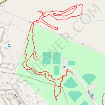
Exploring George Poston Park
- Distance: 3.1 mi
- Elevation gain: 335 ft
- Maximum elevation: 889 ft
- Elevation loss: 331 ft
- Minimum elevation: 728 ft
- Moving time: 1 h 2 m
- Moving speed: 2.9 mph
- Maximum speed: 4.6 mph
- Total time: 1 h 7 m
- Global speed: 2.8 mph
Interactive trail map
Thank you for supporting this site ❤️
Make a donation
Make a donation
Gear up for your next adventure:
As an Amazon Associate, this site earns from qualifying purchases at no extra cost to you.
Trail profile
- Distance: 3.1 mi
- Elevation gain: 335 ft
- Maximum elevation: 889 ft
- Elevation loss: 331 ft
- Minimum elevation: 728 ft
- Moving time: 1 h 2 m
- Moving speed: 2.9 mph
- Maximum speed: 4.6 mph
- Total time: 1 h 7 m
- Global speed: 2.8 mph
Thank you for supporting this site ❤️
Make a donation
Make a donation
Gear up for your next adventure:
As an Amazon Associate, this site earns from qualifying purchases at no extra cost to you.
About this trail
Name: Exploring George Poston Park trail, distance, elevation, map, profile, GPS track
Start: Tower Road, Gaston County, North Carolina, 28098, United States (35.28972 -81.11272)
End: Tower Road, Gaston County, North Carolina, 28098, United States (35.28993 -81.11310)
Coordinates: 35.28747 -81.11770 35.29540 -81.11172
Topography: Gaston County topographic map, elevation, terrain
Thank you for supporting this site ❤️
Make a donation
Make a donation
Gear up for your next adventure:
As an Amazon Associate, this site earns from qualifying purchases at no extra cost to you.