Mount Pilchuck Trail
Mount Pilchuck Trail begins from the forest road trailhead and climbs through evergreen woodland, crossing small drainages before entering steeper, rockier alpine terrain on the mountain’s upper slopes. The route then bends across open talus and exposed ridgeline terrain toward the Mount Pilchuck summit, where the historic fire lookout is the main landmark. On a clear day, the reward is a broad Cascade panorama, with views toward Puget Sound, the Olympic Mountains, Mount Baker, and Mount Rainier.
#Lookout #Summit #Ridge #Forest #Panorama #Trail #Hiking #Mountain #Nature
- Distance: 5.7 mi
- Elevation gain: 2,218 ft
- Maximum elevation: 5,246 ft
- Elevation loss: 2,221 ft
- Minimum elevation: 3,140 ft
- Moving time: 3 h 56 m
- Moving speed: 1.5 mph
- Maximum speed: 3.6 mph
- Total time: 5 h 1 m
- Global speed: 1.1 mph
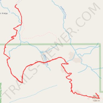
Interactive trail map
Trail profile
- Distance: 5.7 mi
- Elevation gain: 2,218 ft
- Maximum elevation: 5,246 ft
- Elevation loss: 2,221 ft
- Minimum elevation: 3,140 ft
- Moving time: 3 h 56 m
- Moving speed: 1.5 mph
- Maximum speed: 3.6 mph
- Total time: 5 h 1 m
- Global speed: 1.1 mph
About this trail
Name: Mount Pilchuck Trail trail, distance, elevation, map, profile, GPS track
Start: Mount Pilchuck Trail #700, Snohomish County, Washington, United States (48.07021 -121.81468)
Coordinates: 48.05722 -121.81713 48.07041 -121.79711
Topography: Snohomish County topographic map, elevation, terrain
Other hiking, mountain biking, running and outdoor activity trails
Click on a trail to view its statistics, map and profile.
Mount Pilchuck Trail in Mount Baker-Snoqualmie National Forest
United States > Washington > Snohomish County
The Mount Pilchuck Trail offers hikers a challenging yet rewarding adventure through the forests and rocky terrain of Washington's Mount Baker-Snoqualmie National Forest. As you ascend, you'll experience a variety of landscapes, including dense old-growth forest, boulder fields, and expansive alpine meadows,…
Distance: 5.3 mi • Elevation gain: 2,178 ft • Maximum elevation: 5,249 ft
Northern part of the Pacific Crest Trail (PCT)
United States > Oregon > Klamath County
Hike on the Pacific Crest National Scenic Trail from Crater Lake to Canada Border through Oregon and Washington along the Sierra Nevada and Cascade mountain ranges. #Hiking #Mountain #SierraNevada #Cascade #Nature #Forest #Park #PCT
Distance: 744.6 mi • Elevation gain: 145,367 ft • Maximum elevation: 7,569 ft
Mount Pilchuck
United States > Washington > Snohomish County
Mount Pilchuck State Park. Mount Baker Snoqualmie National Forest. #Hiking #Snowshoeing #Mountain #Forest #Nature
Distance: 4.9 mi • Elevation gain: 2,146 ft • Maximum elevation: 5,246 ft
Mount Pilchuck Trail
United States > Washington > Snohomish County
Distance: 5.6 mi • Elevation gain: 2,234 ft • Maximum elevation: 5,249 ft