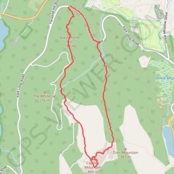
Cadillac Mountain Loop (Mount Desert Island)
Loop hike to Cadillac Mountain via Cadillac North Ridge Trail, Great Pond Hill and Gorge Path in the Acadia National Park. #Hiking #Loop #Mountain #Island #Forest #Park #Lake
- Distance: 4.9 mi
- Elevation gain: 1,296 ft
- Maximum elevation: 1,493 ft
- Elevation loss: 1,306 ft
- Minimum elevation: 233 ft
- Moving time: 2 h 4 m
- Moving speed: 2.4 mph
- Maximum speed: 6.8 mph
- Total time: 2 h 46 m
- Global speed: 1.8 mph
Interactive trail map
Trail profile
- Distance: 4.9 mi
- Elevation gain: 1,296 ft
- Maximum elevation: 1,493 ft
- Elevation loss: 1,306 ft
- Minimum elevation: 233 ft
- Moving time: 2 h 4 m
- Moving speed: 2.4 mph
- Maximum speed: 6.8 mph
- Total time: 2 h 46 m
- Global speed: 1.8 mph
About this trail
Name: Cadillac Mountain Loop (Mount Desert Island) trail, distance, elevation, map, profile, GPS track
End: Park Loop Road, Bar Harbor, Hancock County, Maine, 04609, United States (44.37855 -68.22930)
Coordinates: 44.35141 -68.23150 44.37855 -68.21894
Topography: Hancock County topographic map, elevation, terrain
Other hiking, mountain biking, running and outdoor activity trails
Click on a trail to view its statistics, map and profile.
Cadillac Mountain Summit via Cadillac South Ridge Trail in Acadia National Park
United States > Maine > Hancock County > Mount Desert
The Cadillac Mountain South Ridge Trail in Acadia National Park offers hikers a rewarding journey through diverse landscapes, including white pine and spruce forests, the Featherbed pond, open granite ridges, and culminating in panoramic vistas from the summit. The trail begins with a gentle ascent through…
Distance: 7.0 mi • Elevation gain: 1,457 ft • Maximum elevation: 1,509 ft
Cadillac Mountain via Cadillac North Ridge Trail in Acadia National Park
United States > Maine > Hancock County > Bar Harbor
The Cadillac North Ridge Trail in Acadia National Park offers hikers a steady ascent through serene forests and exposed granite ridges, providing expansive views of Frenchman Bay and the surrounding islands. As you approach the summit of Cadillac Mountain, the highest point on the U.S. East Coast, panoramic…
Distance: 4.8 mi • Elevation gain: 1,171 ft • Maximum elevation: 1,493 ft
Cadillac Mountain via Cadillac North Ridge Trail in Acadia National Park
United States > Maine > Hancock County > Bar Harbor
Hiking the Cadillac North Ridge Trail in Acadia National Park offers a mix of scenic beauty and physical challenge. As you ascend, you'll be surrounded by lush forests and striking pink granite formations, with several viewpoints providing breathtaking looks at Frenchman Bay, Bar Harbor and the surrounding…
Distance: 4.5 mi • Elevation gain: 1,122 ft • Maximum elevation: 1,503 ft
Cadillac Mountain via Cadillac South Ridge Trail in Acadia National Park
United States > Maine > Hancock County > Mount Desert
The Cadillac South Ridge Trail offers a captivating journey to the summit of Cadillac Mountain in Acadia National Park, with a diverse landscape that transitions from lush forests to exposed granite ridges. Hikers can enjoy spectacular views of the Gulf of Maine and nearby islands, especially as they ascend…
Distance: 7.1 mi • Elevation gain: 1,457 ft • Maximum elevation: 1,506 ft
Cadillac Mountain Loop via A Murray Young Path, Canon Brook Trail and Cadillac South Ridge Trail
United States > Maine > Hancock County > Bar Harbor
Distance: 3.9 mi • Elevation gain: 1,325 ft • Maximum elevation: 1,506 ft
Acadia loop trail via Cadillac Mountain
United States > Maine > Hancock County > Bar Harbor
Distance: 6.4 mi • Elevation gain: 1,742 ft • Maximum elevation: 1,503 ft
Cadillac Mountain Loop Trail
United States > Maine > Hancock County > Bar Harbor
Distance: 7.5 mi • Elevation gain: 1,850 ft • Maximum elevation: 1,506 ft