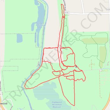
Englewood MetroPark trails
- Distance: 8.5 mi
- Elevation gain: 620 ft
- Maximum elevation: 965 ft
- Elevation loss: 620 ft
- Minimum elevation: 781 ft
- Moving time: 2 h 44 m
- Moving speed: 3.1 mph
- Maximum speed: 8.9 mph
- Total time: 2 h 44 m
- Global speed: 3.1 mph
Interactive trail map
Trail profile
- Distance: 8.5 mi
- Elevation gain: 620 ft
- Maximum elevation: 965 ft
- Elevation loss: 620 ft
- Minimum elevation: 781 ft
- Moving time: 2 h 44 m
- Moving speed: 3.1 mph
- Maximum speed: 8.9 mph
- Total time: 2 h 44 m
- Global speed: 3.1 mph
About this trail
Name: Englewood MetroPark trails trail, distance, elevation, map, profile, GPS track
Start: Pattys Road, Butler Township, Montgomery County, Ohio, 45322, United States (39.88319 -84.28620)
End: Pattys Road, Butler Township, Montgomery County, Ohio, 45322, United States (39.88317 -84.28619)
Coordinates: 39.87704 -84.29606 39.89700 -84.28052
Topography: Montgomery County topographic map, elevation, terrain