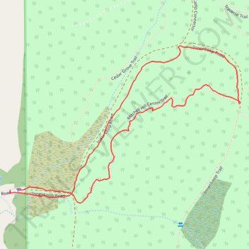
Mitchell Hill Center Trail and Inner Loop Road
- Distance: 0.9 mi
- Elevation gain: 151 ft
- Maximum elevation: 236 ft
- Elevation loss: 154 ft
- Minimum elevation: 82 ft
- Moving time: 26 m 48 s
- Moving speed: 2.0 mph
- Maximum speed: 2.9 mph
- Total time: 31 m 12 s
- Global speed: 1.7 mph
Interactive trail map
Trail profile
- Distance: 0.9 mi
- Elevation gain: 151 ft
- Maximum elevation: 236 ft
- Elevation loss: 154 ft
- Minimum elevation: 82 ft
- Moving time: 26 m 48 s
- Moving speed: 2.0 mph
- Maximum speed: 2.9 mph
- Total time: 31 m 12 s
- Global speed: 1.7 mph
About this trail
Name: Mitchell Hill Center Trail and Inner Loop Road trail, distance, elevation, map, profile, GPS track
Start: Horse Trail Road, San Juan County, Washington, United States (48.57222 -123.13756)
End: 83, Horse Trail Road, San Juan County, Washington, 98250, United States (48.57220 -123.13773)
Coordinates: 48.57196 -123.13776 48.57485 -123.13138
Topography: San Juan County topographic map, elevation, terrain