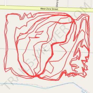
Momentum Bike Park - Zora Side
- Distance: 7.8 mi
- Elevation gain: 666 ft
- Maximum elevation: 994 ft
- Elevation loss: 666 ft
- Minimum elevation: 922 ft
- Moving time: 50 m 57 s
- Moving speed: 9.2 mph
- Maximum speed: 23.0 mph
- Total time: 1 h 1 m
- Global speed: 7.7 mph
Interactive trail map
Trail profile
- Distance: 7.8 mi
- Elevation gain: 666 ft
- Maximum elevation: 994 ft
- Elevation loss: 666 ft
- Minimum elevation: 922 ft
- Moving time: 50 m 57 s
- Moving speed: 9.2 mph
- Maximum speed: 23.0 mph
- Total time: 1 h 1 m
- Global speed: 7.7 mph
About this trail
Name: Momentum Bike Park - Zora Side trail, distance, elevation, map, profile, GPS track
Start: Adventure Ln, Joplin, Jasper County, Missouri, 64801, United States (37.11132 -94.51949)
End: Adventure Ln, Joplin, Jasper County, Missouri, 64801, United States (37.11113 -94.51949)
Coordinates: 37.11096 -94.52115 37.11379 -94.51669
Topography: Joplin topographic map, elevation, terrain