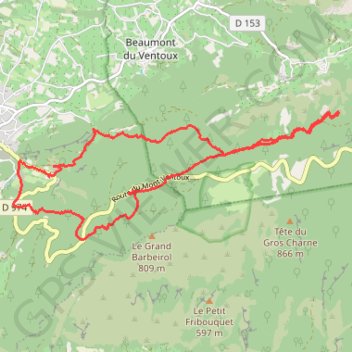
Malaucene
- Distance: 9.1 mi
- Elevation gain: 2,188 ft
- Maximum elevation: 2,510 ft
- Elevation loss: 2,201 ft
- Minimum elevation: 1,240 ft
Interactive trail map
Trail profile
- Distance: 9.1 mi
- Elevation gain: 2,188 ft
- Maximum elevation: 2,510 ft
- Elevation loss: 2,201 ft
- Minimum elevation: 1,240 ft
About this trail
Name: Malaucene trail, distance, elevation, map, profile, GPS track
Coordinates: 44.15880 5.14105 44.17579 5.20142
Other hiking, mountain biking, running and outdoor activity trails
Click on a trail to view its statistics, map and profile.
1 LUCENA - MONTPELLIER
Distance: 1,842.0 mi • Elevation gain: 96,785 ft • Maximum elevation: 3,438 ft
PT23DS2 Lörrach → Cadaqués
Germany > Baden-Württemberg > Landkreis Lörrach > Lörrach (Kernstadt)
Distance: 652.9 mi • Elevation gain: 43,077 ft • Maximum elevation: 4,938 ft
Chemin de Saint-Jacques-de-Compostelle
Switzerland > Geneva > Geneva
Distance: 694.6 mi • Elevation gain: 82,881 ft • Maximum elevation: 4,692 ft
Mont Ventoux - all 3 sides
France > Provence-Alpes-Côte d'Azur > Vaucluse > Bédoin
Distance: 82.3 mi • Elevation gain: 14,780 ft • Maximum elevation: 6,224 ft