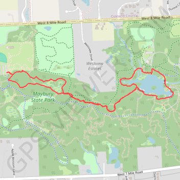
Maybury Hiking Loop Trail in Maybury State Park
The Maybury Hiking Trail offers a peaceful escape into nature, winding through a variety of landscapes including dense woods, open grasslands, and scenic views of a pond. Along the route, hikers can observe a rich diversity of wildlife, including various bird species, and in the spring, the forest floor comes alive with vibrant trilliums. The trail provides a gentle, well-maintained path, making it an ideal choice for those looking to enjoy a quiet, natural experience without too much difficulty. #Hiking #Loop #Lake #Forest #Nature
- Distance: 3.1 mi
- Elevation gain: 151 ft
- Maximum elevation: 978 ft
- Elevation loss: 151 ft
- Minimum elevation: 892 ft
- Moving time: 1 h 19 m
- Moving speed: 2.4 mph
- Maximum speed: 3.7 mph
- Total time: 1 h 20 m
- Global speed: 2.3 mph
Interactive trail map
Trail profile
- Distance: 3.1 mi
- Elevation gain: 151 ft
- Maximum elevation: 978 ft
- Elevation loss: 151 ft
- Minimum elevation: 892 ft
- Moving time: 1 h 19 m
- Moving speed: 2.4 mph
- Maximum speed: 3.7 mph
- Total time: 1 h 20 m
- Global speed: 2.3 mph
About this trail
Name: Maybury Hiking Loop Trail in Maybury State Park trail, distance, elevation, map, profile, GPS track
Coordinates: 42.42789 -83.53525 42.43180 -83.51500
Topography: Wayne County topographic map, elevation, terrain