Make a donation
Gear up for your next adventure:
As an Amazon Associate, this site earns from qualifying purchases at no extra cost to you.
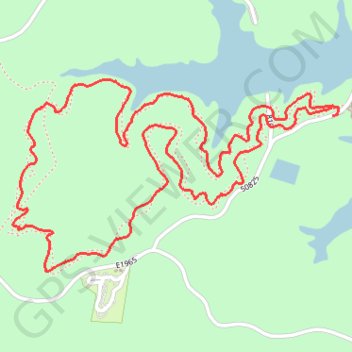
Lakeview Lodge Loop Trail in Hochatown State Park
The Lakeview Lodge Loop Trail offers a delightful hiking experience with its blend of natural beauty and accessibility. Hikers can enjoy panoramic views of Lake Broken Bow while traversing through lush forests filled with diverse flora and fauna, making it a peaceful escape into nature. The trail's well-maintained paths are suitable for all skill levels, allowing families and casual hikers to appreciate the serene landscape without challenging terrain. #Hiking #Loop #Lake #Forest #Nature
- Distance: 3.8 mi
- Elevation gain: 374 ft
- Maximum elevation: 784 ft
- Elevation loss: 377 ft
- Minimum elevation: 620 ft
- Moving time: 1 h 32 m
- Moving speed: 2.5 mph
- Maximum speed: 4.8 mph
- Total time: 1 h 34 m
- Global speed: 2.4 mph
Interactive trail map
Make a donation
Gear up for your next adventure:
As an Amazon Associate, this site earns from qualifying purchases at no extra cost to you.
Trail profile
- Distance: 3.8 mi
- Elevation gain: 374 ft
- Maximum elevation: 784 ft
- Elevation loss: 377 ft
- Minimum elevation: 620 ft
- Moving time: 1 h 32 m
- Moving speed: 2.5 mph
- Maximum speed: 4.8 mph
- Total time: 1 h 34 m
- Global speed: 2.4 mph
Make a donation
Gear up for your next adventure:
As an Amazon Associate, this site earns from qualifying purchases at no extra cost to you.
About this trail
Name: Lakeview Lodge Loop Trail in Hochatown State Park trail, distance, elevation, map, profile, GPS track
Start: Lakeview Lodge Trail, McCurtain County, Oklahoma, United States (34.17420 -94.72550)
End: 50825, McCurtain County, Oklahoma, United States (34.17393 -94.72544)
Coordinates: 34.16806 -94.73999 34.17527 -94.72519
Topography: McCurtain County topographic map, elevation, terrain
Make a donation
Gear up for your next adventure:
As an Amazon Associate, this site earns from qualifying purchases at no extra cost to you.