Make a donation
Gear up for your next adventure:
As an Amazon Associate, this site earns from qualifying purchases at no extra cost to you.
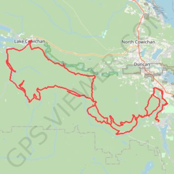
Robertson River Falls dual sport ride (not BBF)
Full day dual sport loop, from Shawnigan to Robertson River Falls and back. Not BBF due to gates and Hillclimb.
- Distance: 127.2 mi
- Elevation gain: 17,257 ft
- Maximum elevation: 2,575 ft
- Elevation loss: 17,257 ft
- Minimum elevation: 46 ft
- Moving time: 6 h 3 m
- Moving speed: 21.0 mph
- Maximum speed: 50.5 mph
- Total time: 8 h 24 m
- Global speed: 15.1 mph
Interactive trail map
Make a donation
Gear up for your next adventure:
As an Amazon Associate, this site earns from qualifying purchases at no extra cost to you.
Trail profile
- Distance: 127.2 mi
- Elevation gain: 17,257 ft
- Maximum elevation: 2,575 ft
- Elevation loss: 17,257 ft
- Minimum elevation: 46 ft
- Moving time: 6 h 3 m
- Moving speed: 21.0 mph
- Maximum speed: 50.5 mph
- Total time: 8 h 24 m
- Global speed: 15.1 mph
Make a donation
Gear up for your next adventure:
As an Amazon Associate, this site earns from qualifying purchases at no extra cost to you.
About this trail
Name: Robertson River Falls dual sport ride (not BBF) trail, distance, elevation, map, profile, GPS track
Coordinates: 48.63435 -124.12815 48.82868 -123.62893
Make a donation
Gear up for your next adventure:
As an Amazon Associate, this site earns from qualifying purchases at no extra cost to you.
Other hiking, mountain biking, running and outdoor activity trails
Click on a trail to view its statistics, map and profile.
Cobble Hill Loop
Canada > British Columbia > Cowichan Valley Regional District > Area C (Cobble Hill) > Cobble Hill
Cobble Hill Mountain Regional Recreation Area. #Hiking #MTB #Loop #CobbleHill
Distance: 4.5 mi • Elevation gain: 1,066 ft • Maximum elevation: 1,050 ft
Mount Prevost
Canada > British Columbia > Cowichan Valley Regional District > North Cowichan
North Cowichan Municipal Forest Reserve. Vancouver Island. #Hiking #Loop #NorthCowichan #Vancouver
Distance: 6.7 mi • Elevation gain: 2,303 ft • Maximum elevation: 2,454 ft
Make a donation
Gear up for your next adventure:
As an Amazon Associate, this site earns from qualifying purchases at no extra cost to you.
BBF loop to the Skydeck in Nanaimo
Canada > British Columbia > Cowichan Valley Regional District > Area A (Mill Bay / Malahat) > Mill Bay
BBF loop to the Skydeck
Distance: 201.0 mi • Elevation gain: 20,413 ft • Maximum elevation: 2,316 ft