Thank you for supporting this site ❤️
Make a donation
Make a donation
Gear up for your next adventure:
As an Amazon Associate, this site earns from qualifying purchases at no extra cost to you.
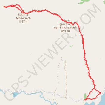
Munro hillwalk Sgurr Mhaoriach
Interactive trail map
Thank you for supporting this site ❤️
Make a donation
Make a donation
Gear up for your next adventure:
As an Amazon Associate, this site earns from qualifying purchases at no extra cost to you.
Trail profile
- Distance: 10.0 mi
- Elevation gain: 3,609 ft
- Maximum elevation: 3,346 ft
- Elevation loss: 3,609 ft
- Minimum elevation: 692 ft
- Moving time: 4 h 50 m
- Moving speed: 2.1 mph
- Maximum speed: 5.9 mph
- Total time: 5 h 4 m
- Global speed: 2.0 mph
Thank you for supporting this site ❤️
Make a donation
Make a donation
Gear up for your next adventure:
As an Amazon Associate, this site earns from qualifying purchases at no extra cost to you.
About this trail
Name: Munro hillwalk Sgurr Mhaoriach trail, distance, elevation, map, profile, GPS track
Start: Highland, Scotland, United Kingdom (57.07720 -5.29433)
End: Highland, Scotland, United Kingdom (57.07718 -5.29421)
Coordinates: 57.07707 -5.34172 57.10761 -5.28449
Thank you for supporting this site ❤️
Make a donation
Make a donation
Gear up for your next adventure:
As an Amazon Associate, this site earns from qualifying purchases at no extra cost to you.