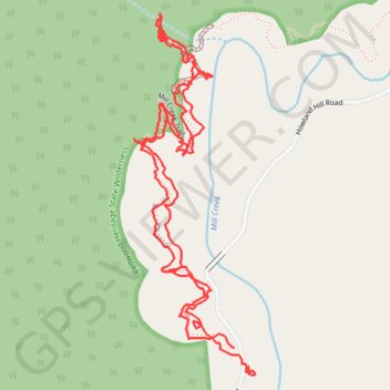
Grove of Titans
- Distance: 2.2 mi
- Elevation gain: 236 ft
- Maximum elevation: 295 ft
- Elevation loss: 226 ft
- Minimum elevation: 210 ft
- Moving time: 58 m 9 s
- Moving speed: 2.3 mph
- Maximum speed: 7.7 mph
- Total time: 1 h 9 s
- Global speed: 2.2 mph
Interactive trail map
Trail profile
- Distance: 2.2 mi
- Elevation gain: 236 ft
- Maximum elevation: 295 ft
- Elevation loss: 226 ft
- Minimum elevation: 210 ft
- Moving time: 58 m 9 s
- Moving speed: 2.3 mph
- Maximum speed: 7.7 mph
- Total time: 1 h 9 s
- Global speed: 2.2 mph
About this trail
Name: Grove of Titans trail, distance, elevation, map, profile, GPS track
Start: Howland Hill Road, Del Norte County, California, United States (41.77196 -124.09900)
End: Mill Creek Trail, Del Norte County, California, United States (41.77249 -124.09941)
Coordinates: 41.77194 -124.10207 41.77909 -124.09883
Topography: Del Norte County topographic map, elevation, terrain