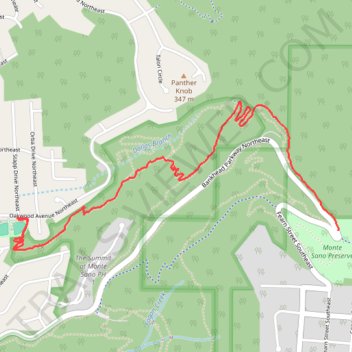
Bankhead Trail and Oak Park Trail MTB Ride in Monte Sano Nature Preserve
- Distance: 2.8 mi
- Elevation gain: 138 ft
- Maximum elevation: 1,352 ft
- Elevation loss: 784 ft
- Minimum elevation: 702 ft
- Moving time: 24 m 10 s
- Moving speed: 7.0 mph
- Maximum speed: 17.7 mph
- Total time: 29 m 16 s
- Global speed: 5.8 mph
Interactive trail map
Trail profile
- Distance: 2.8 mi
- Elevation gain: 138 ft
- Maximum elevation: 1,352 ft
- Elevation loss: 784 ft
- Minimum elevation: 702 ft
- Moving time: 24 m 10 s
- Moving speed: 7.0 mph
- Maximum speed: 17.7 mph
- Total time: 29 m 16 s
- Global speed: 5.8 mph
About this trail
Name: Bankhead Trail and Oak Park Trail MTB Ride in Monte Sano Nature Preserve trail, distance, elevation, map, profile, GPS track
End: Oak Park, Huntsville, Madison County, Alabama, 35801, United States (34.74857 -86.54962)
Coordinates: 34.74692 -86.54986 34.75456 -86.52947
Topography: Huntsville topographic map, elevation, terrain
Other hiking, mountain biking, running and outdoor activity trails
Click on a trail to view its statistics, map and profile.
25 mile Bike Ride, Huntsville/Gurley AL
United States > Alabama > Madison County > Huntsville > Five Points
Moontown Airport
Distance: 25.2 mi • Elevation gain: 1,237 ft • Maximum elevation: 1,007 ft
Toll Gate Greenway MTB in Monte Sano State Park
United States > Alabama > Madison County > Huntsville > Oak Park
Distance: 2.6 mi • Elevation gain: 538 ft • Maximum elevation: 1,460 ft
Land Trust Ride
United States > Alabama > Madison County > Huntsville
Distance: 11.8 mi • Elevation gain: 1,578 ft • Maximum elevation: 1,621 ft