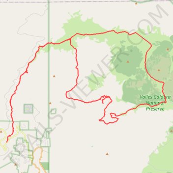
San Antonio Hot Springs + Valles Caldera Loop
- Distance: 44.2 mi
- Elevation gain: 4,642 ft
- Maximum elevation: 9,656 ft
- Elevation loss: 4,642 ft
- Minimum elevation: 8,274 ft
- Moving time: 6 h 15 m
- Moving speed: 7.1 mph
- Maximum speed: 25.8 mph
- Total time: 8 h 29 m
- Global speed: 5.2 mph
Interactive trail map
Trail profile
- Distance: 44.2 mi
- Elevation gain: 4,642 ft
- Maximum elevation: 9,656 ft
- Elevation loss: 4,642 ft
- Minimum elevation: 8,274 ft
- Moving time: 6 h 15 m
- Moving speed: 7.1 mph
- Maximum speed: 25.8 mph
- Total time: 8 h 29 m
- Global speed: 5.2 mph
About this trail
Name: San Antonio Hot Springs + Valles Caldera Loop trail, distance, elevation, map, profile, GPS track
Start: Lake Fork Canyon Road, Sandoval County, New Mexico, United States (35.88155 -106.66523)
End: Lake Fork Canyon Road, Sandoval County, New Mexico, United States (35.88158 -106.66525)
Coordinates: 35.88151 -106.66529 35.97563 -106.49860
Topography: Sandoval County topographic map, elevation, terrain