Thank you for supporting this site ❤️
Make a donation
Make a donation
Gear up for your next adventure:
As an Amazon Associate, this site earns from qualifying purchases at no extra cost to you.
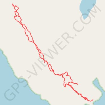
Gloomy Knob Hike
Afternoon Hike
- Distance: 2.8 mi
- Elevation gain: 1,424 ft
- Maximum elevation: 1,312 ft
- Elevation loss: 1,401 ft
- Minimum elevation: 26 ft
- Moving time: 1 h 45 m
- Moving speed: 1.6 mph
- Maximum speed: 4.0 mph
- Total time: 2 h 33 m
- Global speed: 1.1 mph
Interactive trail map
Thank you for supporting this site ❤️
Make a donation
Make a donation
Gear up for your next adventure:
As an Amazon Associate, this site earns from qualifying purchases at no extra cost to you.
Trail profile
- Distance: 2.8 mi
- Elevation gain: 1,424 ft
- Maximum elevation: 1,312 ft
- Elevation loss: 1,401 ft
- Minimum elevation: 26 ft
- Moving time: 1 h 45 m
- Moving speed: 1.6 mph
- Maximum speed: 4.0 mph
- Total time: 2 h 33 m
- Global speed: 1.1 mph
Thank you for supporting this site ❤️
Make a donation
Make a donation
Gear up for your next adventure:
As an Amazon Associate, this site earns from qualifying purchases at no extra cost to you.
About this trail
Name: Gloomy Knob Hike trail, distance, elevation, map, profile, GPS track
Start: Unorganized Borough, Alaska, United States (58.82711 -136.45614)
End: Unorganized Borough, Alaska, United States (58.82704 -136.45727)
Coordinates: 58.82696 -136.47272 58.83726 -136.45614
Topography: Unorganized Borough topographic map, elevation, terrain
Thank you for supporting this site ❤️
Make a donation
Make a donation
Gear up for your next adventure:
As an Amazon Associate, this site earns from qualifying purchases at no extra cost to you.