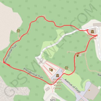
Mount Rushmore Presidential Trail
This loop trail is a delightful way to get up close and personal with the iconic monument. As you stroll along the paved path, you can admire the stunning views of the presidential faces from various angles and read interesting historical tidbits about each leader. While the stairs can be a bit of a workout, the scenery and historical insights make it well worth the effort, offering a unique and memorable experience. #Hiking #Loop #Rock #Nature
- Distance: 0.6 mi
- Elevation gain: 148 ft
- Maximum elevation: 5,305 ft
- Elevation loss: 148 ft
- Minimum elevation: 5,157 ft
- Moving time: 20 m 40 s
- Moving speed: 1.7 mph
- Maximum speed: 14.7 mph
- Total time: 23 m 15 s
- Global speed: 1.5 mph
Interactive trail map
Trail profile
- Distance: 0.6 mi
- Elevation gain: 148 ft
- Maximum elevation: 5,305 ft
- Elevation loss: 148 ft
- Minimum elevation: 5,157 ft
- Moving time: 20 m 40 s
- Moving speed: 1.7 mph
- Maximum speed: 14.7 mph
- Total time: 23 m 15 s
- Global speed: 1.5 mph
About this trail
Name: Mount Rushmore Presidential Trail trail, distance, elevation, map, profile, GPS track
Start: Grand View Terrace, Pennington County, South Dakota, 57751, United States (43.87696 -103.45617)
End: Grand View Terrace, Pennington County, South Dakota, 57751, United States (43.87695 -103.45618)
Coordinates: 43.87685 -103.45840 43.87894 -103.45443
Topography: Pennington County topographic map, elevation, terrain