Thank you for supporting this site ❤️
Make a donation
Make a donation
Gear up for your next adventure:
As an Amazon Associate, this site earns from qualifying purchases at no extra cost to you.
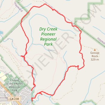
Dry Creek Pioneer Regional Park Loop Hike
- Distance: 5.4 mi
- Elevation gain: 1,155 ft
- Maximum elevation: 1,168 ft
- Elevation loss: 1,109 ft
- Minimum elevation: 125 ft
- Moving time: 2 h 5 m
- Moving speed: 2.6 mph
- Maximum speed: 5.4 mph
- Total time: 2 h 25 m
- Global speed: 2.2 mph
Interactive trail map
Thank you for supporting this site ❤️
Make a donation
Make a donation
Gear up for your next adventure:
As an Amazon Associate, this site earns from qualifying purchases at no extra cost to you.
Trail profile
- Distance: 5.4 mi
- Elevation gain: 1,155 ft
- Maximum elevation: 1,168 ft
- Elevation loss: 1,109 ft
- Minimum elevation: 125 ft
- Moving time: 2 h 5 m
- Moving speed: 2.6 mph
- Maximum speed: 5.4 mph
- Total time: 2 h 25 m
- Global speed: 2.2 mph
Thank you for supporting this site ❤️
Make a donation
Make a donation
Gear up for your next adventure:
As an Amazon Associate, this site earns from qualifying purchases at no extra cost to you.
About this trail
Name: Dry Creek Pioneer Regional Park Loop Hike trail, distance, elevation, map, profile, GPS track
Coordinates: 37.60820 -122.02114 37.63155 -122.00195
Topography: Alameda County topographic map, elevation, terrain
Thank you for supporting this site ❤️
Make a donation
Make a donation
Gear up for your next adventure:
As an Amazon Associate, this site earns from qualifying purchases at no extra cost to you.