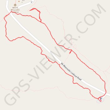
Mount Wooroolin main tracks
- Distance: 1.4 mi
- Elevation gain: 312 ft
- Maximum elevation: 1,798 ft
- Elevation loss: 312 ft
- Minimum elevation: 1,526 ft
- Moving time: 41 m 55 s
- Moving speed: 2.0 mph
- Maximum speed: 3.2 mph
- Total time: 43 m 44 s
- Global speed: 1.9 mph
Interactive trail map
Trail profile
- Distance: 1.4 mi
- Elevation gain: 312 ft
- Maximum elevation: 1,798 ft
- Elevation loss: 312 ft
- Minimum elevation: 1,526 ft
- Moving time: 41 m 55 s
- Moving speed: 2.0 mph
- Maximum speed: 3.2 mph
- Total time: 43 m 44 s
- Global speed: 1.9 mph
About this trail
Name: Mount Wooroolin main tracks trail, distance, elevation, map, profile, GPS track
Coordinates: -26.53014 151.80599 -26.52520 151.81200
Other hiking, mountain biking, running and outdoor activity trails
Click on a trail to view its statistics, map and profile.
Kingaroy Taabinga Boonenne trace
Australia > Queensland > Kingaroy
Loop bike around Kingaroy. #Bike #Loop #Countryside #Nature #Forest
Distance: 22.9 mi • Elevation gain: 1,207 ft • Maximum elevation: 1,778 ft
Murgon - Kingaroy
Australia > Queensland > Murgon
#Bike
Distance: 30.1 mi • Elevation gain: 1,099 ft • Maximum elevation: 1,604 ft
Memerambi to Ushers Hill
Memerambi, Crawford, Kingaroy, Taabinga, Queensland
Distance: 29.3 mi • Elevation gain: 1,089 ft • Maximum elevation: 1,860 ft
Taabinga and Wattle Grove
Australia > Queensland > Kingaroy
Kingaroy, Taabinga, Inverlaw, Wattle Grove
Distance: 33.7 mi • Elevation gain: 1,555 ft • Maximum elevation: 1,778 ft
Kingaroy - East Wooroolin
Australia > Queensland > Kingaroy
Distance: 26.5 mi • Elevation gain: 1,624 ft • Maximum elevation: 1,857 ft
Memerambi
Australia > Queensland > Kingaroy
West side Memerambi and Crawford
Distance: 23.6 mi • Elevation gain: 965 ft • Maximum elevation: 1,831 ft