Sag Valley Yellow Loop Trail in Swallow Cliff Woods
The Sag Valley Yellow Loop Trail offers hikers a refreshing experience through a diverse landscape, characterized by rolling hills, lush forests, and scenic vistas. As you traverse the loop, you may encounter a variety of wildlife and plant species, particularly in the spring and fall when the flora is most vibrant. This tranquil setting, combined with the challenge of some moderately hilly terrain, makes it a rewarding escape into nature for all skill levels. #Hiking #Loop #Forest #Nature
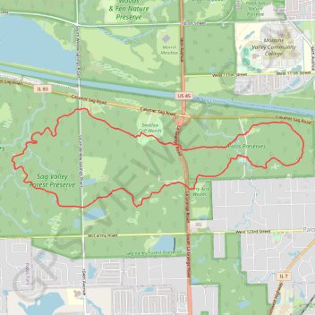
- Distance: 7.8 mi
- Elevation gain: 436 ft
- Maximum elevation: 732 ft
- Elevation loss: 436 ft
- Minimum elevation: 604 ft
- Moving time: 2 h 36 m
- Moving speed: 3.0 mph
- Maximum speed: 4.5 mph
- Total time: 2 h 37 m
- Global speed: 3.0 mph
Interactive trail map
Trail profile
- Distance: 7.8 mi
- Elevation gain: 436 ft
- Maximum elevation: 732 ft
- Elevation loss: 436 ft
- Minimum elevation: 604 ft
- Moving time: 2 h 36 m
- Moving speed: 3.0 mph
- Maximum speed: 4.5 mph
- Total time: 2 h 37 m
- Global speed: 3.0 mph
About this trail
Name: Sag Valley Yellow Loop Trail in Swallow Cliff Woods trail, distance, elevation, map, profile, GPS track
Coordinates: 41.67043 -87.88729 41.68424 -87.83309
Topography: Cook County topographic map, elevation, terrain