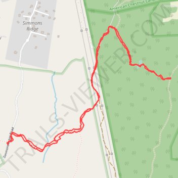
Prince Frederick Trail
- Distance: 3.8 mi
- Elevation gain: 367 ft
- Maximum elevation: 148 ft
- Elevation loss: 367 ft
- Minimum elevation: 59 ft
- Moving time: 1 h 36 m
- Moving speed: 2.4 mph
- Maximum speed: 3.8 mph
- Total time: 1 h 47 m
- Global speed: 2.2 mph
Interactive trail map
Trail profile
- Distance: 3.8 mi
- Elevation gain: 367 ft
- Maximum elevation: 148 ft
- Elevation loss: 367 ft
- Minimum elevation: 59 ft
- Moving time: 1 h 36 m
- Moving speed: 2.4 mph
- Maximum speed: 3.8 mph
- Total time: 1 h 47 m
- Global speed: 2.2 mph
About this trail
Name: Prince Frederick Trail trail, distance, elevation, map, profile, GPS track
Coordinates: 38.53774 -76.55846 38.54824 -76.54085
Topography: Calvert County topographic map, elevation, terrain
Other hiking, mountain biking, running and outdoor activity trails
Click on a trail to view its statistics, map and profile.
Parkers Creek loop trail
United States > Maryland > Calvert County
Distance: 3.4 mi • Elevation gain: 276 ft • Maximum elevation: 151 ft