Thank you for supporting this site ❤️
Make a donation
Make a donation
Gear up for your next adventure:
As an Amazon Associate, this site earns from qualifying purchases at no extra cost to you.
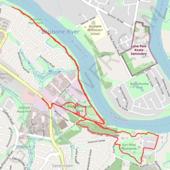
Rocks Riverside
Brisbane Trail Run
- Distance: 7.0 mi
- Elevation gain: 650 ft
- Maximum elevation: 210 ft
- Elevation loss: 650 ft
- Minimum elevation: 20 ft
- Moving time: 1 h 15 m
- Moving speed: 5.6 mph
- Maximum speed: 10.6 mph
- Total time: 1 h 18 m
- Global speed: 5.4 mph
Interactive trail map
Thank you for supporting this site ❤️
Make a donation
Make a donation
Gear up for your next adventure:
As an Amazon Associate, this site earns from qualifying purchases at no extra cost to you.
Trail profile
- Distance: 7.0 mi
- Elevation gain: 650 ft
- Maximum elevation: 210 ft
- Elevation loss: 650 ft
- Minimum elevation: 20 ft
- Moving time: 1 h 15 m
- Moving speed: 5.6 mph
- Maximum speed: 10.6 mph
- Total time: 1 h 18 m
- Global speed: 5.4 mph
Thank you for supporting this site ❤️
Make a donation
Make a donation
Gear up for your next adventure:
As an Amazon Associate, this site earns from qualifying purchases at no extra cost to you.
About this trail
Name: Rocks Riverside trail, distance, elevation, map, profile, GPS track
Coordinates: -27.54898 152.95097 -27.52990 152.97107
Thank you for supporting this site ❤️
Make a donation
Make a donation
Gear up for your next adventure:
As an Amazon Associate, this site earns from qualifying purchases at no extra cost to you.