Thank you for supporting this site ❤️
Make a donation
Make a donation
Gear up for your next adventure:
As an Amazon Associate, this site earns from qualifying purchases at no extra cost to you.
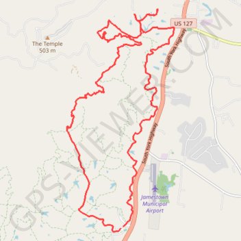
Fentress County
East Fork
- Distance: 15.7 mi
- Elevation gain: 1,749 ft
- Maximum elevation: 1,729 ft
- Elevation loss: 1,745 ft
- Minimum elevation: 889 ft
Interactive trail map
Thank you for supporting this site ❤️
Make a donation
Make a donation
Gear up for your next adventure:
As an Amazon Associate, this site earns from qualifying purchases at no extra cost to you.
Trail profile
- Distance: 15.7 mi
- Elevation gain: 1,749 ft
- Maximum elevation: 1,729 ft
- Elevation loss: 1,745 ft
- Minimum elevation: 889 ft
Thank you for supporting this site ❤️
Make a donation
Make a donation
Gear up for your next adventure:
As an Amazon Associate, this site earns from qualifying purchases at no extra cost to you.
About this trail
Name: Fentress County trail, distance, elevation, map, profile, GPS track
Start: 172, D, Fentress County, Middle Tennessee, Tennessee, United States (36.33867 -84.95666)
End: Fentress County, Middle Tennessee, Tennessee, United States (36.33902 -84.95607)
Coordinates: 36.33779 -84.97313 36.39225 -84.94053
Topography: Fentress County topographic map, elevation, terrain
Thank you for supporting this site ❤️
Make a donation
Make a donation
Gear up for your next adventure:
As an Amazon Associate, this site earns from qualifying purchases at no extra cost to you.