Make a donation
Gear up for your next adventure:
As an Amazon Associate, this site earns from qualifying purchases at no extra cost to you.
St Cloud Running
Stearns co path
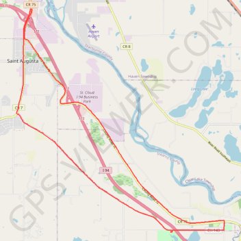
- Distance: 15.9 mi
- Elevation gain: 361 ft
- Maximum elevation: 1,027 ft
- Elevation loss: 361 ft
- Minimum elevation: 958 ft
- Moving time: 3 h 41 m
- Moving speed: 4.3 mph
- Maximum speed: 8.6 mph
- Total time: 3 h 43 m
- Global speed: 4.3 mph
Interactive trail map
Make a donation
Gear up for your next adventure:
As an Amazon Associate, this site earns from qualifying purchases at no extra cost to you.
Trail profile
- Distance: 15.9 mi
- Elevation gain: 361 ft
- Maximum elevation: 1,027 ft
- Elevation loss: 361 ft
- Minimum elevation: 958 ft
- Moving time: 3 h 41 m
- Moving speed: 4.3 mph
- Maximum speed: 8.6 mph
- Total time: 3 h 43 m
- Global speed: 4.3 mph
Make a donation
Gear up for your next adventure:
As an Amazon Associate, this site earns from qualifying purchases at no extra cost to you.
About this trail
Name: St Cloud Running trail, distance, elevation, map, profile, GPS track
Start: 43rd Street South, St. Cloud, Stearns County, Minnesota, 56301, United States (45.49528 -94.14980)
End: 43rd Street South, St. Cloud, Stearns County, Minnesota, 56301, United States (45.49531 -94.14977)
Coordinates: 45.42286 -94.15688 45.49531 -94.06061
Topography: St. Cloud topographic map, elevation, terrain
Make a donation
Gear up for your next adventure:
As an Amazon Associate, this site earns from qualifying purchases at no extra cost to you.