Thank you for supporting this site ❤️
Make a donation
Make a donation
Gear up for your next adventure:
As an Amazon Associate, this site earns from qualifying purchases at no extra cost to you.
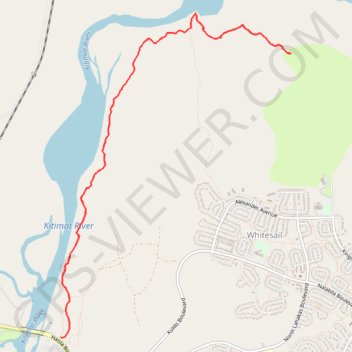
Fishermen's Trail
Kitimat River. #Hiking
- Distance: 6.6 mi
- Elevation gain: 1,148 ft
- Maximum elevation: 295 ft
- Elevation loss: 1,148 ft
- Minimum elevation: 79 ft
Interactive trail map
Thank you for supporting this site ❤️
Make a donation
Make a donation
Gear up for your next adventure:
As an Amazon Associate, this site earns from qualifying purchases at no extra cost to you.
Trail profile
- Distance: 6.6 mi
- Elevation gain: 1,148 ft
- Maximum elevation: 295 ft
- Elevation loss: 1,148 ft
- Minimum elevation: 79 ft
Thank you for supporting this site ❤️
Make a donation
Make a donation
Gear up for your next adventure:
As an Amazon Associate, this site earns from qualifying purchases at no extra cost to you.
About this trail
Name: Fishermen's Trail trail, distance, elevation, map, profile, GPS track
Coordinates: 54.05849 -128.67303 54.08630 -128.63943
Thank you for supporting this site ❤️
Make a donation
Make a donation
Gear up for your next adventure:
As an Amazon Associate, this site earns from qualifying purchases at no extra cost to you.