Chatauqua Peak - Clematis Falls
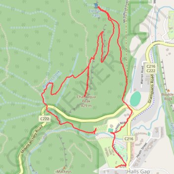
Interactive trail map
Trail profile
- Distance: 3.8 mi
- Elevation gain: 771 ft
- Maximum elevation: 1,325 ft
- Elevation loss: 781 ft
- Minimum elevation: 764 ft
- Moving time: 1 h 44 m
- Moving speed: 2.2 mph
- Maximum speed: 31.5 mph
- Total time: 2 h 53 m
- Global speed: 1.3 mph
About this trail
Name: Chatauqua Peak - Clematis Falls trail, distance, elevation, map, profile, GPS track
Coordinates: -37.14140 142.50910 -37.12660 142.51951
Other hiking, mountain biking, running and outdoor activity trails
Click on a trail to view its statistics, map and profile.
Venus Baths, Boroka Lookout, Lake Wartook Lookout, Werdug, Grampians Peaks Trail
Australia > Victoria > Halls Gap
GPT
Distance: 16.7 mi • Elevation gain: 3,576 ft • Maximum elevation: 2,792 ft
Halls Gap, The Pinnacle, Mount Rosea and Bellfield Lake loop
Australia > Victoria > Halls Gap
Distance: 18.9 mi • Elevation gain: 3,668 ft • Maximum elevation: 3,241 ft
Splitters Falls, Grand Canyon, Pinnacle, Sundial loop
Australia > Victoria > Halls Gap
Distance: 11.7 mi • Elevation gain: 2,316 ft • Maximum elevation: 2,536 ft