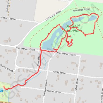
Caravan Park -> Dunkeld Arboretum
- Distance: 1.8 mi
- Elevation gain: 46 ft
- Maximum elevation: 827 ft
- Elevation loss: 46 ft
- Minimum elevation: 794 ft
- Moving time: 47 m 23 s
- Moving speed: 2.2 mph
- Maximum speed: 3.9 mph
- Total time: 54 m 46 s
- Global speed: 1.9 mph
Interactive trail map
Trail profile
- Distance: 1.8 mi
- Elevation gain: 46 ft
- Maximum elevation: 827 ft
- Elevation loss: 46 ft
- Minimum elevation: 794 ft
- Moving time: 47 m 23 s
- Moving speed: 2.2 mph
- Maximum speed: 3.9 mph
- Total time: 54 m 46 s
- Global speed: 1.9 mph
About this trail
Name: Caravan Park -> Dunkeld Arboretum trail, distance, elevation, map, profile, GPS track
Coordinates: -37.64895 142.34571 -37.64401 142.35350
Other hiking, mountain biking, running and outdoor activity trails
Click on a trail to view its statistics, map and profile.
Dunkeld Mount Sturgeon Loop in Grampians National Park
Australia > Victoria > Dunkeld
Distance: 8.3 mi • Elevation gain: 1,591 ft • Maximum elevation: 1,864 ft