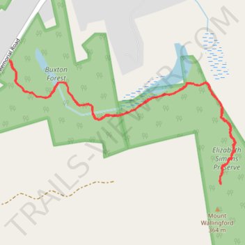
Mount Wallingford Trail gps track
- Distance: 2.8 mi
- Elevation gain: 604 ft
- Maximum elevation: 1,168 ft
- Elevation loss: 604 ft
- Minimum elevation: 745 ft
- Moving time: 1 h 13 m
- Moving speed: 2.3 mph
- Maximum speed: 3.8 mph
- Total time: 1 h 27 m
- Global speed: 1.9 mph
Interactive trail map
Trail profile
- Distance: 2.8 mi
- Elevation gain: 604 ft
- Maximum elevation: 1,168 ft
- Elevation loss: 604 ft
- Minimum elevation: 745 ft
- Moving time: 1 h 13 m
- Moving speed: 2.3 mph
- Maximum speed: 3.8 mph
- Total time: 1 h 27 m
- Global speed: 1.9 mph
About this trail
Name: Mount Wallingford Trail gps track trail, distance, elevation, map, profile, GPS track
Coordinates: 43.07472 -71.74941 43.08121 -71.73318
Topography: Hillsborough County topographic map, elevation, terrain