Thank you for supporting this site ❤️
Make a donation
Make a donation
Gear up for your next adventure:
As an Amazon Associate, this site earns from qualifying purchases at no extra cost to you.
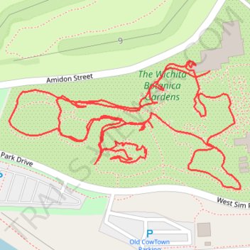
Wichita botanic gardens loop
- Distance: 1.5 mi
- Elevation gain: 16 ft
- Maximum elevation: 1,319 ft
- Elevation loss: 16 ft
- Minimum elevation: 1,306 ft
- Moving time: 46 m 35 s
- Moving speed: 1.9 mph
- Maximum speed: 3.7 mph
- Total time: 59 m 27 s
- Global speed: 1.5 mph
Interactive trail map
Thank you for supporting this site ❤️
Make a donation
Make a donation
Gear up for your next adventure:
As an Amazon Associate, this site earns from qualifying purchases at no extra cost to you.
Trail profile
- Distance: 1.5 mi
- Elevation gain: 16 ft
- Maximum elevation: 1,319 ft
- Elevation loss: 16 ft
- Minimum elevation: 1,306 ft
- Moving time: 46 m 35 s
- Moving speed: 1.9 mph
- Maximum speed: 3.7 mph
- Total time: 59 m 27 s
- Global speed: 1.5 mph
Thank you for supporting this site ❤️
Make a donation
Make a donation
Gear up for your next adventure:
As an Amazon Associate, this site earns from qualifying purchases at no extra cost to you.
About this trail
Name: Wichita botanic gardens loop trail, distance, elevation, map, profile, GPS track
Coordinates: 37.69457 -97.36719 37.69629 -97.36326
Topography: Wichita topographic map, elevation, terrain
Thank you for supporting this site ❤️
Make a donation
Make a donation
Gear up for your next adventure:
As an Amazon Associate, this site earns from qualifying purchases at no extra cost to you.