Thank you for supporting this site ❤️
Make a donation
Make a donation
Gear up for your next adventure:
As an Amazon Associate, this site earns from qualifying purchases at no extra cost to you.
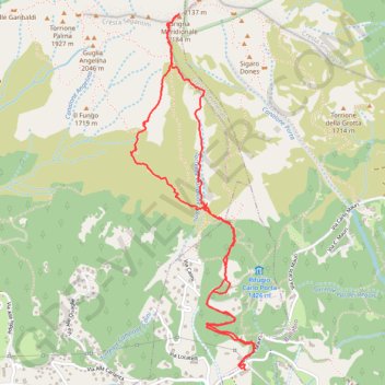
Traccia corrente: 13 MAR 2016 07:40
- Distance: 3.9 mi
- Elevation gain: 2,966 ft
- Maximum elevation: 7,064 ft
- Elevation loss: 2,959 ft
- Minimum elevation: 4,213 ft
- Moving time: 2 h 41 m
- Moving speed: 1.4 mph
- Maximum speed: 3.8 mph
- Total time: 4 h 38 m
- Global speed: 0.8 mph
Interactive trail map
Thank you for supporting this site ❤️
Make a donation
Make a donation
Gear up for your next adventure:
As an Amazon Associate, this site earns from qualifying purchases at no extra cost to you.
Trail profile
- Distance: 3.9 mi
- Elevation gain: 2,966 ft
- Maximum elevation: 7,064 ft
- Elevation loss: 2,959 ft
- Minimum elevation: 4,213 ft
- Moving time: 2 h 41 m
- Moving speed: 1.4 mph
- Maximum speed: 3.8 mph
- Total time: 4 h 38 m
- Global speed: 0.8 mph
Thank you for supporting this site ❤️
Make a donation
Make a donation
Gear up for your next adventure:
As an Amazon Associate, this site earns from qualifying purchases at no extra cost to you.
About this trail
Name: Traccia corrente: 13 MAR 2016 07:40 trail, distance, elevation, map, profile, GPS track
Start: Via Carlo Mauri, Ballabio, Lecco, Lombardy, 23811, Italy (45.90569 9.39508)
Coordinates: 45.90569 9.38755 45.92199 9.39570
Thank you for supporting this site ❤️
Make a donation
Make a donation
Gear up for your next adventure:
As an Amazon Associate, this site earns from qualifying purchases at no extra cost to you.