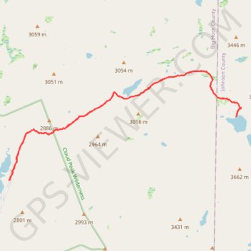
Lost Twin Lakes Trail
Big Horn County Trail Running
- Distance: 11.3 mi
- Elevation gain: 2,041 ft
- Maximum elevation: 10,436 ft
- Elevation loss: 2,041 ft
- Minimum elevation: 9,127 ft
- Moving time: 2 h 59 m
- Moving speed: 3.8 mph
- Maximum speed: 9.4 mph
- Total time: 3 h 29 m
- Global speed: 3.2 mph
Interactive trail map
Trail profile
- Distance: 11.3 mi
- Elevation gain: 2,041 ft
- Maximum elevation: 10,436 ft
- Elevation loss: 2,041 ft
- Minimum elevation: 9,127 ft
- Moving time: 2 h 59 m
- Moving speed: 3.8 mph
- Maximum speed: 9.4 mph
- Total time: 3 h 29 m
- Global speed: 3.2 mph
About this trail
Name: Lost Twin Lakes Trail trail, distance, elevation, map, profile, GPS track
Start: Mistymoon Trail, Big Horn County, Wyoming, United States (44.26248 -107.21280)
End: Mistymoon Trail, Big Horn County, Wyoming, United States (44.26245 -107.21276)
Coordinates: 44.26245 -107.21280 44.28848 -107.13572
Topography: Big Horn County topographic map, elevation, terrain