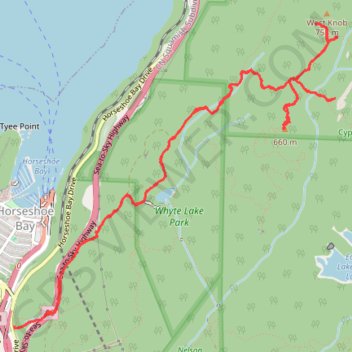
West Knob and Whyte Lake
Hike to West Knob and Whyte Lake via Baden Powel Trail, Whyte Lake Trail, Rock Pile, Donut Rock Trail and West Knob Access in the Whyte Lake Park and the Cypress Provincial Park. #Hiking #Mountain #Lake #Nature #Forest #Park
- Distance: 7.1 mi
- Elevation gain: 2,349 ft
- Maximum elevation: 2,362 ft
- Elevation loss: 2,336 ft
- Minimum elevation: 240 ft
- Moving time: 3 h 53 m
- Moving speed: 1.8 mph
- Maximum speed: 8.8 mph
- Total time: 5 h 15 m
- Global speed: 1.4 mph
Interactive trail map
Trail profile
- Distance: 7.1 mi
- Elevation gain: 2,349 ft
- Maximum elevation: 2,362 ft
- Elevation loss: 2,336 ft
- Minimum elevation: 240 ft
- Moving time: 3 h 53 m
- Moving speed: 1.8 mph
- Maximum speed: 8.8 mph
- Total time: 5 h 15 m
- Global speed: 1.4 mph
About this trail
Name: West Knob and Whyte Lake trail, distance, elevation, map, profile, GPS track
Coordinates: 49.36688 -123.27518 49.38781 -123.24092
Other hiking, mountain biking, running and outdoor activity trails
Click on a trail to view its statistics, map and profile.