Thank you for supporting this site ❤️
Make a donation
Make a donation
Gear up for your next adventure:
As an Amazon Associate, this site earns from qualifying purchases at no extra cost to you.
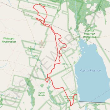
Copicut Miller Brook
- Distance: 9.1 mi
- Elevation gain: 348 ft
- Maximum elevation: 272 ft
- Elevation loss: 344 ft
- Minimum elevation: 148 ft
- Moving time: 1 h 29 m
- Moving speed: 6.1 mph
- Maximum speed: 15.7 mph
- Total time: 1 h 38 m
- Global speed: 5.5 mph
Interactive trail map
Thank you for supporting this site ❤️
Make a donation
Make a donation
Gear up for your next adventure:
As an Amazon Associate, this site earns from qualifying purchases at no extra cost to you.
Trail profile
- Distance: 9.1 mi
- Elevation gain: 348 ft
- Maximum elevation: 272 ft
- Elevation loss: 344 ft
- Minimum elevation: 148 ft
- Moving time: 1 h 29 m
- Moving speed: 6.1 mph
- Maximum speed: 15.7 mph
- Total time: 1 h 38 m
- Global speed: 5.5 mph
Thank you for supporting this site ❤️
Make a donation
Make a donation
Gear up for your next adventure:
As an Amazon Associate, this site earns from qualifying purchases at no extra cost to you.
About this trail
Name: Copicut Miller Brook trail, distance, elevation, map, profile, GPS track
Coordinates: 41.69837 -71.06406 41.73447 -71.04345
Topography: Fall River topographic map, elevation, terrain
Thank you for supporting this site ❤️
Make a donation
Make a donation
Gear up for your next adventure:
As an Amazon Associate, this site earns from qualifying purchases at no extra cost to you.
Other hiking, mountain biking, running and outdoor activity trails
Click on a trail to view its statistics, map and profile.
Copicut Miller Brook
United States > Massachusetts > Bristol County > Fall River
Distance: 10.0 mi • Elevation gain: 476 ft • Maximum elevation: 302 ft