Thank you for supporting this site ❤️
Make a donation
Make a donation
Gear up for your next adventure:
As an Amazon Associate, this site earns from qualifying purchases at no extra cost to you.
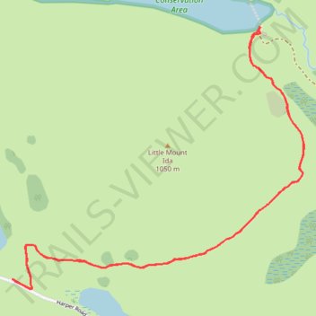
Ryton Track to Lake Ida in Glenthorne Station
- Distance: 3.5 mi
- Elevation gain: 604 ft
- Maximum elevation: 2,339 ft
- Elevation loss: 600 ft
- Minimum elevation: 1,955 ft
- Moving time: 1 h 32 m
- Moving speed: 2.3 mph
- Maximum speed: 2.9 mph
- Total time: 2 h 30 m
- Global speed: 1.4 mph
Interactive trail map
Thank you for supporting this site ❤️
Make a donation
Make a donation
Gear up for your next adventure:
As an Amazon Associate, this site earns from qualifying purchases at no extra cost to you.
Trail profile
- Distance: 3.5 mi
- Elevation gain: 604 ft
- Maximum elevation: 2,339 ft
- Elevation loss: 600 ft
- Minimum elevation: 1,955 ft
- Moving time: 1 h 32 m
- Moving speed: 2.3 mph
- Maximum speed: 2.9 mph
- Total time: 2 h 30 m
- Global speed: 1.4 mph
Thank you for supporting this site ❤️
Make a donation
Make a donation
Gear up for your next adventure:
As an Amazon Associate, this site earns from qualifying purchases at no extra cost to you.
About this trail
Name: Ryton Track to Lake Ida in Glenthorne Station trail, distance, elevation, map, profile, GPS track
Start: Ryton Track, Selwyn District, New Zealand (-43.24752 171.52712)
End: Ryton Track, Selwyn District, New Zealand (-43.24751 171.52723)
Coordinates: -43.24796 171.52712 -43.23601 171.54537
Thank you for supporting this site ❤️
Make a donation
Make a donation
Gear up for your next adventure:
As an Amazon Associate, this site earns from qualifying purchases at no extra cost to you.
Other hiking, mountain biking, running and outdoor activity trails
Click on a trail to view its statistics, map and profile.