Thank you for supporting this site ❤️
Make a donation
Make a donation
Gear up for your next adventure:
As an Amazon Associate, this site earns from qualifying purchases at no extra cost to you.
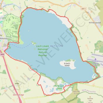
Gravel Ride - Loch Leven Circular
- Distance: 12.5 mi
- Elevation gain: 354 ft
- Maximum elevation: 410 ft
- Elevation loss: 354 ft
- Minimum elevation: 335 ft
- Moving time: 1 h 31 m
- Moving speed: 8.2 mph
- Maximum speed: 17.4 mph
- Total time: 1 h 36 m
- Global speed: 7.7 mph
Interactive trail map
Thank you for supporting this site ❤️
Make a donation
Make a donation
Gear up for your next adventure:
As an Amazon Associate, this site earns from qualifying purchases at no extra cost to you.
Trail profile
- Distance: 12.5 mi
- Elevation gain: 354 ft
- Maximum elevation: 410 ft
- Elevation loss: 354 ft
- Minimum elevation: 335 ft
- Moving time: 1 h 31 m
- Moving speed: 8.2 mph
- Maximum speed: 17.4 mph
- Total time: 1 h 36 m
- Global speed: 7.7 mph
Thank you for supporting this site ❤️
Make a donation
Make a donation
Gear up for your next adventure:
As an Amazon Associate, this site earns from qualifying purchases at no extra cost to you.
About this trail
Name: Gravel Ride - Loch Leven Circular trail, distance, elevation, map, profile, GPS track
Start: Nan Walker Wynd, Kinross, Perth and Kinross, Scotland, KY13 8FF, United Kingdom (56.19946 -3.41746)
End: Nan Walker Wynd, Kinross, Perth and Kinross, Scotland, KY13 8FF, United Kingdom (56.19944 -3.41744)
Coordinates: 56.17184 -3.42110 56.22040 -3.32617
Thank you for supporting this site ❤️
Make a donation
Make a donation
Gear up for your next adventure:
As an Amazon Associate, this site earns from qualifying purchases at no extra cost to you.